Peru's rainforest highway triggers surge in deforestation, according to new 3D forest mapping
From mongabay.com
Scientists using a combination of satellite imagery, airborne-laser technology, and ground-based plot surveys to create three-dimensional high resolution carbon maps of the Amazon rainforest have documented a surge in emissions from deforestation and selective logging following the paving of the Trans-Oceanic Highway in Peru.
The study, published this week in the early edition of the Proceedings of the National Academy of Sciences, reveals that selective logging and other forms of forest degradation in Peru account for nearly a third of emissions compared to deforestation alone. The findings, which demonstrate the feasibility of using LiDAR and satellite imagery over large areas of tropical forest, have important implications for monitoring, reporting, and verifying emissions reductions under proposed Reduced Emissions from Deforestation and Degradation (REDD) programs, which could compensate developing countries for protecting and sustainability managing their forests.
"We've demonstrated that a cost-effective use of airborne LiDAR and free satellite data can speed up the process of carbon mapping and greatly reduce uncertainties in tracking carbon emissions from land-use change in the humid tropics," lead author Greg Asner, a researcher at the Carnegie Institution's Department of Global Ecology at Stanford University, told mongabay.com. "The role of laborious and expensive field plots can also be reduced to a subset for calibrating the LiDAR to regional biomass conditions."
"Most importantly, the method can be picked up by others, including governments wishing to participate in REDD-type programs. We are working with the Ministries in Peru, Colombia and Ecuador now."
Asner and colleagues used a four-step process to map emissions over over 4.3 million ha of the Peruvian Amazon, an area twice that of all forests in Costa Rica. The vegetation types and disturbance were measured by satellite; the 3-D vegetation structure was mapped using the LiDAR system (light detection and ranging) aboard the Carnegie Airborne Observatory, a small airplane; the data was ground-truthed using field plots on the ground; and the satellite and LiDAR data was integrated to create "high resolution maps of stored and emitted carbon," according to a statement from the Carnegie Institution.
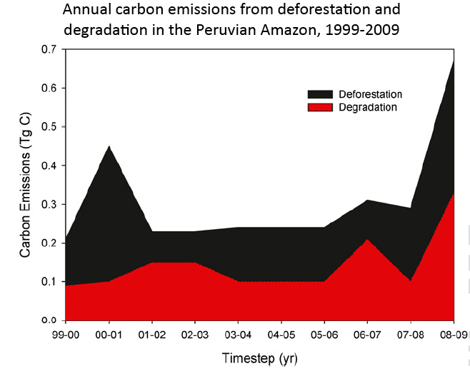
The work shows that some 4.5 million metric tons of aboveground carbon were committed to the atmosphere due to deforestation and forest degradation from 1999 to 2009. Degradation emissions averaged 47% of deforestation emissions over the period, but were offset by forest regrowth, which accounted for 812 million tons of carbon sequestration. Net emissions over the period were thus 3.7 million tons, or roughly the annual emissions of the country of Jamaica.
The research reveals a spike in emissions from deforestation and forest degradation in the Peruvian Amazon in 2009. The increase appears to be associated with the paving of the Trans-Oceanic Highway, which connects the Amazon to Pacific coast ports, facilitating the transport of soy, timber, cattle, and other commodities. The project, which has been partially funded by China, has led to a proliferation in logging, clearing for agriculture, gold mining, and exploration for oil and gas in southeastern Peru. Environmentalists fear the highway will exacerbate forest exploitation in a region where trees lock up massive amounts carbon.
"We found that the total regional forest carbon storage was about 395 million metric tons and emissions reached about 630,000 metric tons per year," Asner said in a statement, adding that the analysis shows current estimates of carbon stored in the vegetation of the Peruvian Amazon are too high by about a third. These estimates are used as a baseline by the Intergovernmental Panel on Climate Change (IPCC) for determining emissions reductions under the proposed REDD mechanism.
The authors also uncovered previously recognized patterns of aboveground biomass distribution, notably that forest growing on geologically younger, more fertile surfaces, stores more carbon that forest growing on ancient soils.
"What really surprised us was how carbon storage differed among forest types and the underlying geology, all in very close proximity to one another," said Asner, who is also using the system to remotely inventory tree biodiversity across the region.
Asner and his team are now expanding their research outside the Amazon. They have benefited from falling technology costs.
"The cost to implement this method of high-resolution carbon stock and emissions monitoring is decreasing. Satellite data costs are decreasing, and the major data sources are now free of charge to end users. The cost for analyzing the satellite data for forest cover, deforestation and degradation is also rapidly diminishing," the authors write, noting that the Carnegie Institution's Landsat Analysis System Lite (CLASlite) for analyzing satellite data is available free to non-profits working in the Amazon region.
Costs of LiDAR are also diminishing.
"For this 4.3 million ha analysis, the Carnegie Airborne Observatory (CAO) operated its LiDAR, processed the data, and provided maps of forest structure at a cost of less than $0.08/ha," the authors write. "More recent work in Madagascar has reduced the cost to approximately $0.06/ha, and there exists a strong economy-of-scale effect whereby larger-area projects prove far more cost effective than small-area analyses. This runs opposite to plot-level work, which increases in cost on a per-area basis."
The authors conclude with a call to map the Peruvian Amazon's entire 60 million hectares.
REFERENCE:
Asner GP. PWell GVN, Mascaro J, Knapp DE, Clark JK, Jacobson J, Kennedy-Bowdoin T, Balaji A, Paez-Acosta G, Victoria E, Secada L, Valqui M, Hughes RF (2010) High-resolution forest carbon stocks and emissions in the Amazon. Proceedings of the National Academy of Sciences


No comments:
Post a Comment